The municipality of S. Pedro do Sul is located in the central interior of Portugal, in the district of Viseu, in the Lafões region. It has an area of 348.68 square kilometres distributed in 14 parishes: Bordonhos, Figueiredo de Alva, Manhouce, Pindelo dos Milagres, Pinho, S. Félix, Serrazes, Sul, Union of Parishes of Carvalhais and Candal, Union of Parishes of S. Martinho of Moitas and Covas do Rio, Union of Parishes of S. Pedro do Sul, Várzea and Baiões, Valadares and Vila Maior.
It is bordered to the north by the municipality of Castro Daire, the Southeast by Viseu, the South by Vouzela, the south and the west by Oliveira de Frades, the west by Vale de Cambra and the Northwest by Arouca.
Open on google mapsLigações rodoviárias
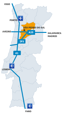
Servida por modernos acessos por auto-estrada, a S. Pedro do Sul está a cómodas distâncias das principais cidades do Ocidente Ibérico:
- 2:30 hours of Lisboa (305 Kms via A8/A17/A25);
- 2:30 hours of (290 Kms via A1/A25);
- 60 minutes from Porto (120 Kms via A1/A25);
- 2:10 hours of Salamanca (260 Kms Via E80/A25);
- 2:00 hours ofBadajoz (240 Kms);
- 2:40 hours ofCáceres (319 Kms).
If you take the A8, take the A17 and A25, leaving at exit 13 towards S. Pedro do Sul.
If you drive on the A1 you will have the option of choosing two main routes – IP3 (Coimbra Zone) and A25. By IP3, you can leave at the Tondela node (Exit Campo de Besteiros). From the A25 you can exit at exit no13 towards S. Pedro do Sul.
If you take the EN 228 towards S. Pedro do Sul or take the exit at Viseu node and take the EN 16 towards S. Pedro do Sul.

RAIL CONNECTIONS
From Lisbon
(Station of Stª Apolónia ou Gare do Oriente) – Line of Beira Alta – Arrival at Nelas or Mangualde.
(Staion of de Campanhã) – Transhipment to Beira Alta Line in Pampilhosa or Coimbra B – Arrival in Nelas or Mangualde.


@termassps
Follow Us
@termassps
Instagram